GPS Water Vapor
GPS Water Vapor Sounding (Zugspitze 47.42 °N, 10.98 °E, 2964 m a.s.l. and Garmisch 47.48 °N, 11.06 °E, 745 m a.s.l.)
GPS receiver equipment for water sounding was installed in 2002 according to the specifications of the currently established network within the German GPS Atmospheric Sounding Project (GASP, Reigber 1999-2002). This includes dual frequency GPS receivers (1.6- and 1.2-GHz signals), antenna, antenna mount, and a dedicated computer connected to the web to maintain real-time data flow via ftp. Installation of receivers both at the Zugspitze mountain site and the Garmisch ground-station allows to characterize the water columns above 745 m (Garmisch), and above 2964 m a.s.l. (Zugspitze), respectively.
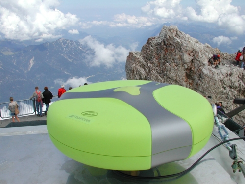
The Zugspitze GPS system consists of a RegAnt-1 Choke Ring Antenna and a Legacy-H GD L1+L2 receiver (Topcon/Allsat Inc., Germany). The second system, installed at Garmisch, was provided by our partners at Geoforschungszentrum Potsdam, Germany and consists of a Ashtech Choke Ring Antenna and a TurboRogue SNR-800 receiver. A GPS receiver raw data file (sample rate 30 seconds) is stored and automatically transferred via ftp every full hour. Retrieval of water vapor vertical columns is performed automatically at Geoforschungszentrum Potsdam and provided back as a file containing the two half hourly means of each hour with a delay of 45 minutes after the full hour:
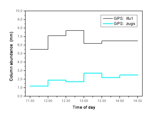
The Figure shows water vapor total column half hourly mean values as a function of time (UTC) from the Garmisch GPS ("ifu1") and the Zugspitze GPS ("zugs"), respectively.